Thursday, October 22, 2009

How Not To Go Up Repack


Trying to go up Repack in Cascade Canyon is a bad idea, but my ungrateful progeny's unwillingness to provide car transport to Pine Ridge forced the issue.

I suppose I should have brought a map, so that I would have reduced the likelihood of going up Cascade Canyon . . . 

and taking a right on Blue Ridge Fire Road:

But I've gotten used to things like pushing my bike up a mile and a half of 40% grade consisting of recently washed riverbed, mud, and slippery rock.

Nice views . . . . 

Steep . . . . 

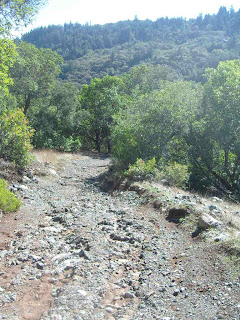
Apparently not well maintained:

Here's what it looks like after you get around the tree:

And the wrong trail:

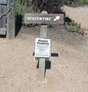
Son of a . . . . this was like having a nightmare about trying to ride the up a down escalator with 4 foot stairs, only to wake up in Tamarancho.  Without the damned day pass . . . . 

Wagon Wheel--the mere thought of which I detest--seemed like the best way out.

An attempt to shortcut B-17  . . . . 

put me right on the fire road that's off limits to non-Boy Scouts . . . . 

eventually ran into Goldman, thence to Alchemist, and several miles off to where I had parked my car.

God damn it!

Monday, October 12, 2009

Kent Lake and Oat Hill fire Road

Talk about a change in weather . . . . sunny and warm last week to bleak and forbidding this week:

Kent Pump Road goes west from Alpine dam.


Bone liquefiying climb up Old Vee Road is available:

There's not a God damned thing at the end except Kent Lake, whose God forsaken shores look like something out of a text book on depression.


Gettin a little Silence of the Lambs vibe here:

So maybe you can ride up Old Vee to Oat Hill Road and take the unmaintained Oat Hill trail down to the road. If not, it's a wasted 750 foot climb in a one mile run.

Here's the intersection with Oat Hill Road.  Go left, and it's two miles to Pine Ridge and thence to Pine Mtn. Loop or on to Repack.

Turn right, well this doesn't look good, but there's probably some kind of trail going down from the official end.

Come to think of it, that ranger fellow did say Oat Trail was impassable:

Christ, with this weather it's like a scene from King Lear up here. "Blow, winds . . . ."

Well maybe this goes somewhere.

Or maybe not. 

Son of a bitch! A cliff with what appears to be the world's larges poison oak grove at the bottom:

Now where the hell is Hansel and Gretel's house?

Saturday, October 10, 2009

Alpine Lake & Pine Ridge

It seems that it's possible to get from the southern edge of the Fairfax golf course up to the road near the Pine Ridge fire trail, which connects to the Pine Mountain loop and to trails going to the brewery in San Gernonimo.

This could be added on at the end of one version of the Lake Loop around the Sky Oaks side of the golf course.

Note Sod-donistas whacking it on would you believe it a day in October:

The beginning of the trail, which goes off Bullfrog, is not advised for cyclists:

However, no one can see you after the first couple hundred feet, and you come out on an unnamed and long unused fire trail that does not appear on maps.

It looks like a good place to practice uphill technical stuff--a fair amount of rocks, but gentle grade.

There are a few sketchy places, like this twenty feet of washed out gravel.

Eventually you come out on the road a few hundred feet from the Pine Ridge trail head.

Ugly hill to get up, but only a couple hundred feet:

Then you can go all the way out to hells have acre, north to intersect with Repack . .

. . . or south towards Kent Lake, which I explored a little:

Wednesday, September 23, 2009

Big Rock Ridge Part I

How to get on Big Rock Ridge without dying or wishing you were dead . . . .

Here's the starting point, going north from Lucas Valley Road near LucasFilms:


Up . .

Several cutbacks:

Views:

After three miles of easy, looping cutbacks seems like you're at the top:

But then there's this:

And This:

And this:

Actually, the photo above is what you see looking back--starting where we left off on the Smith Fire Road circuit makes this whole thing relatively pleasant. At this point I had no desire to go back up that.

But starting at the 650 elevation near LucasFilms means that net-net you're going a lot more down than up.  

More evil hills in part II . . . 

Big Rock Ridge Part II


In the picture below, this is facing east towards where we reached the point on Chicken Shack Fire Road where you stop climbing and descend into Marinwood. It's  pretty far away at this point.


One of many long ass hills you want to make sure you go down--and don't come back.  Unfortunately, there's not avoiding this one:


View east & south from top of Queenstone Fire Road:


Tuesday, December 9, 2008

The Gathering Darkness: Freakish Fraud Events Cloud Year's End


Recent bizarreness in investment fraud seems to be a product of cosmic alignment in the weeks leading to Christmas. This year's manger features a con man with his hand out, lit by a helicopter search light. No angels in the budget this year.


High (or low) points so far:


Pay By Touch honcho John P. Rogers puts the touch on VC investors for $340 million


Attorney Marc Dreier hung out to dry for issuing $100 million in fake notes


Boots Del Biaggio nailed by Feds in $65 million scam


Add your own bailout insanity item here!